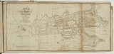
Map of the town of Sydney 1833.
Primary Artist
William Wilson (1795–1867)
Title
Map of the town of Sydney 1833.
Source
The New South Wales calendar and general post office directory. Sydney: Stephens & Stokes, 1834.
Date made
1834Place made
Warrane / Sydney, New South Wales, Australia View on map Close map
Reference
Ferguson (1941-69, 1986),
Category
Illustrated book
Print type
intaglio
Technique
engraving, printed in black ink, from one copper plate
Matrix size
18.0 x 39.2 cm (printed image)
Edition information
print run unknown
Subject categories
Australia, Book arts: Illustrated book | Map
Legacy id
151702
Creators
Wilson, William. | (1795–1867) Australian | British | Male | engraver
Stephens & Stokes. | (1831–) Australian | Organisation | printer
Last Updated
20 Nov 2025
Impressions
Collection
National Gallery of Australia
State
published state
Impression
undesignated impression as issued
view detailed information