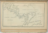
Map of the isthmus of Panama showing the proposed connection of the Pacific and Atlantic oceans.
Primary Artist
Ham Brothers. (1850–1851)
Title
Map of the isthmus of Panama showing the proposed connection of the Pacific and Atlantic oceans.
Source
Ham's illustrated Australian magazine. Melbourne: Ham Brothers, vol.1, 1850.
Page or Plate number
facing p.136
Reference
Ferguson (1941-69, 1986), 5398
Date made
1850Place made
Naam / Melbourne, Victoria, Australia View on map Close map
Category
Illustrated book
Print type
planographic
Technique
lithograph, printed in blue/green ink, from one stone
Matrix size
11.0 x 19.2 cm (printed image)
Edition information
print run unknown
Subject categories
Australia, Book arts: Illustrated book | Map
Legacy id
151735
Creators
Ham Brothers. | (1850–1851) Australian | Organisation | lithographer
Last Updated
20 Nov 2025
Impressions
Collection
National Gallery of Australia
State
published state
Impression
undesignated impression as issued
view detailed information